Aspraggeloi
Built at an altitude of 1.000 m on the slopes of Mount Mitsikeli, on the Mountain Range of Pindos. Until 1927 the village was called Dovra.
First mention about the settlement is in 1380 and growth comes during the 16th & 17th centuries.
During the 19th century, it was a financially flourishing central village. During the German occupation, there was resistance against the Nazis who, in retaliation, burned the village on July 15, 1943, having as a result 115 burnt houses and 2 dead people.
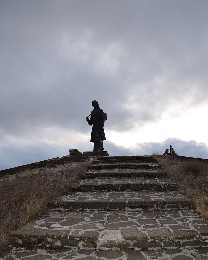
Almost a kilometre before the entrance of the village you will find the the Monument to the Woman of Zagori. The old monastery of Dovra survives in the village, dated back to 1600. On its slopes there are flight schools to help you enjoy glider lessons.
Vitsa
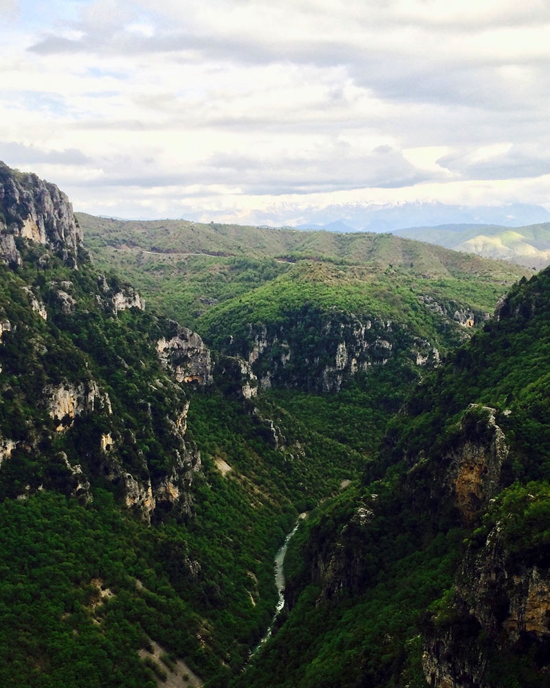
Characterised as a traditional settlement of a special historic, architectural and ecological interest, it is one of the most caracteristic villages of Zagori. Situated at a distance of 36 km from the city of Ioannina, on the road axis of Central Zagori, bordering the National Park of Vikos-Aoos and at the start of the famous Vikos Gorge.
Amphitheatrically built, it impresses the visitor as he wanders around its cobblestone streets. In Vitsa you will also find traditional festivals throughout summer, filling the area with traditional music and dances.

Dikorfo
Dikorfo or Dikoryfo is built at an altitude of 1.000 m on the northeast slopes of Mount Mitsikeli, at a distance of 38 km from Ioannina.
The village’s old name was Ts(i)ontila or Zondila, probably of Albanian/Slavic origin.
The setllement dates back to at least 1431 “Small Tzontila”. Ruins of a fortress and pots of the late roman period have been excavated in the area. It flourished from the 17th to the 19th centuries.
Dilofo
Dilofo is built at an altitude of 900 m on the slopes of Tymfi. Its authentic Zagori identity is what makes it special. The village’s older name until 1920 was Sopotseli, which in Slavic and Vlach means “the place of many waters”.
Elafotopos
Tservari, built at 1150 m, was inhabited around 1200. In 1538 by a High Gate decision it was united to a community, the Tservari community which in 1928 was renamed Elafotopos. To the northwest of the village a fortified settlement survives dated around 300 b.C. and it probably is a Molossi stock farming settlement, during the age Pyrros was the king of Epirus.
In Elafotopos you will find a wonderful Folklore Museum at work since 1993, in the old primary school building. About one thousand objects allocated in 24 different occupation categories are in display. All the old era occupations such as farrier, candle maker, tinker, tin maker, saddler etc are gathered in an attempt to save folklore elements of the greater area.
Kato Pedina
In 1361’s Imperial Decree, the village is listed as Soudena. In a 1627 note, the village is called Stoudena.
Lambridis interpreting the name Stoudena as a “Cold Place”, mentions that the village was called Stoudena until 1634. At the spots of «Gortzia» and «Lakkia Spanou» there are archaeological grave findings dating from the 11th – 12th centuries.
The findings are kept in the Ioannina Archaeological Museum. During the 15th century, its inhabitants migrate along with Ano Soudena inhabitants to Kalavryta Ahaias, because of incidents with a certain Turkish officer.
Passing through K. Pedina, the traveller reaches the village of Aristi (for rafting, kayak, canoe in Voidomatis River) and from there to Papigo village to go hiking on Astraka and Drakolimni, after admiring Kolimvithres (Natural Pools).

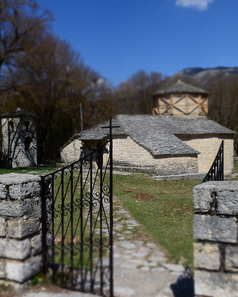
Monodendri
Monodendri knew great financial and merchant prosperity during the 18th and 19th centuries and many churches, schools and mansions were built by its benefactors. The village is the birthplace of national benefactors Manthos and Georgios Rizari.
The Rizari brothers were great merchants whose base was Russia and they allocated their fortune to establish and operate the Risareios Ecclesiastical School. The handicraft school where you can admire or buy beautiful hand woven fabrics and embroideries operates with money from the bequest of the Rizari brothers.
The great Teacher of the Nation, Athanasios Psalidas (1767 – 1829).
Monodendri is one of the most beautiful villages of Zagori with a unique view and numerous visitors every year.
Its caracteristic cobblestone alleys, stone built mansions impress the visitor with their amazing Zagori architecture. The whole village is uniformely built with grey stone. From Monodendri starts a trail leading you to the Vikos Gorge and the Voidomatis River springs, after a delightful hike. The village is the starting point for hiking in the Vikos Gorge and many other climbing and hiking courses. You can admire the beautiful view to the Vikos Gorge right outside the village at Oxia and at the Agia Paraskevi Monastery.
Its amazing views to a scenery of unparalleled beauty make its claim as one of the most beautiful villages of Zagori, true.
Elatohori
Elatohori is built at an altitude of 1.100 m, on the slopes of Tsouka Tzina peak, at a distance of 57 km from the city of Ioannina. Until 1927 the village was called Tsernesi and it is mentioned by this name in the traditional folklore song Fezodervenagas («…the day dawned in Tsernesi…»).
The peak of Tsouka Tzina rises above the village. In the area surrounding Elatohori, there are lakes, stone bridges, rivers and forrests. It is at a close distance from the Tsouka Rosa mountain, verdant with pine trees, fir trees, beech trees, plane trees and with rich fauna including wild boars, hares, bears and other wild animals.
Karyes
Karyes can be found between Miliotades and Kavalari.
This is a mountainous settlement on the southeast slopes of Mount Mitsikeli at an altitude of 630 m. There are running waters and good pastures around it. In 1924 the inhabitants of Ligkiades also migrated to Mogglious. That was the reason many of them escaped the 1943 holocaust.


Eliohori
Dobrinovo (Eliohori) lies at about 70 km northeast of Ioannina, on the slopes of Mount Tymfi, built among verdant nature at an altitude of 900m.
We know that in the middle of the 14th century Cretan monks build the Monastery of Panagia in the village.
In 1943 Germans burned down the village. Between the wars, the situation was difficult.
In 1927, the change of name is being “decided”. Dobrinovo becomes Eliohori.
In October 18 1943 the Germans burn down all the villages of the area and, of course, Eliohori.
One of the most beautiful places in Eliohori are the waterfalls. Three waterfalls form 2 big green pools, in a litteraly virgin forrest. It is a small, beautiful village of Zagori with a peculiar town planning, amphitheatrically built, overlooking Voidomatis River while the impressive northern slope of Gamila peak rises above it.
It offers an Alpine scenery combined with the quiet of the forrest and the intensity of the most impressive mountain tops of Greece.
Kapesovo
Wonderful and traditional, Kapesovo hasn’t got many inhabitants but many beauties to show. Situated close to Vradeto, connected to it by the Vradeto Stairs, one of the most beautiful cobblestone ways of the area. One of the most important sights is the Rigas Feraios Map.
Kapesovo lies at 43 km from Ioannina at an altitude of 1.100 m. Places of interest in Kapesovo are also the library, the Folklore Museum (Paschaleios School) and the Cultural Centre. Its wonderful mansions distinguish it from other villages – the Paschaleios School among them, with its rare books and folklore museum (you will find there one of the four authentic copies of Rigas Velestinlis’ Map). There are ruins of an ancient wall found outside the village, testimonies of its long history.
Kipoi
Kipoi, built at an altitude of 800 m, took its name from the gardens full of fruit baring trees and flowers that all traditional houses have. Bagiotikos River (Vikos tributary) which runs through the village, takes care of all watering needs. Kipoi is in the heart of Central Zagori, where Mounts Mitsikeli and Tymfi of Northern Pindos meet, at a distance of 39 km from Ioannina.
The village of about 70 inhabitants has stone fountains and alleys, a tall bell tower with a clock in the Saint Nicholas churchyard, as well as the “Agapios Tolis” Folklore Museum with its household objects, traditional clothes and many other folklore exhibits.
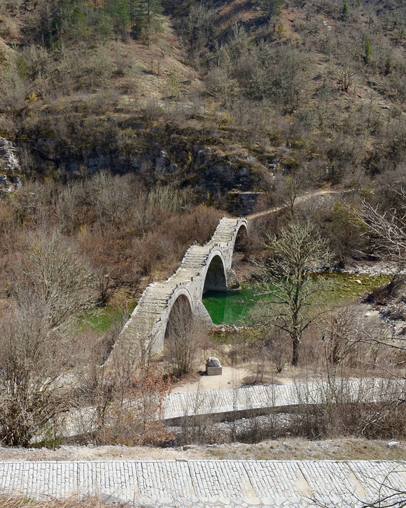
Near Kipoi you will find the most beautiful arched stone bridges of Zagori, like Kontodimos Bridge at the village entrance, at a walking distance from the famous Kokkori (or Noutsou) Bridge, built in 1750, and the three arched Kalogeriko Bridge built in 1748, also known as the “moving caterpillar”.
Those who love hiking head towards the Vikos Gorge for a day long escape, which you may combine with other activities, such as collecting mushrooms. In the summer there is also Zagori Race, a mountain bike race.

Koukouli
Part of the Municipality of Zagori, situated at 38 km of Ioannina and at an altitude of 870 m.
It was already a settlement before 1430, built with a special traditional architecture.
Its name comes from the big rocks (= koukoules, latin Cuculla = wimple) found in the area, or from silk farming that was one of its inhabitants occupation.
In Zagori all stone bridges were built by craftsmen guilds specialised in building bridges, which was difficult and demanded a great deal of art.
Four stone arched bridges over Vikos River belong to Koukouli: Misios Bridge, Noutsou or Kokkorou Bridge, Plakida or Kalogeriko Bridge and Kontodimos or Lazaridis Bridge.
Near these four bridges, one can find four watermills, each named after the respective bridge, which were at the right bank of the river, towards Koukouli.
Negades
At an altitude of 1060 m, on the verdant slope of a hill full of oak trees and in total harmony with the surrounding nature, Negades village is one of the oldest village in Zagori.
Even nowadays the old buildings, mansions and the fabled three nave church of Agios Georgios, unique in all Balkans, tell of a bygone era of cultural growth.
The village was already a settlement in 1312, when it knew an important population growth. During the Ottoman empire period it developped a considerable civilisation and produced many benefactors who succeeded in Moldova, Vlachia, Austria and Russia.
Skamneli
It is situated about 54 km north of Ioannina. It is built on the slopes of Tymfi, next to “Gyftokampos” area.
This area was inhabited since the prehistoric period and the ancient (called Pelasgian) walls found at a close distance from Skamneli are witnesses to that. During the german occupation, the village was burned by them and, as a result, it has lost part of its traditional aura. Nonetheless, there are still many mansions standing, cobblestone alleys and squares. The Agion Apostolon Church, built in 1793, looms over the central square (the middle of the village).

Tsepelovo
Tsepelovo combines the green of the area’s rare flora with the houses and alleys stone grey, giving the impression of natural harmony.
It was built where it stands today in the 14th century. It was the administrative centre of Zagori since the 18th century and flourished culturally and financially during the 18th and 19th century.
The importance people of Tsepelovo paid to education is shown by the fact that poet Ioannis Vilaras (whose grave is in the yard of Tsouflio Pharmacy) found refuge here when hunted by Ali Pasha, as well as the enlightenment scholar Ath.
Psallidas, who taught the village school for two years. And it wasn’t by random choice to found a University right before the Revolution of 1821 in the Monastery of “Ai Giannis of Rogovou”.
Tsepelovo is also the birthplace of Konstantinos Rados, inspirer of founding the Filiki Eteria. One of the many examples of Tsepelovo’s cultural growth, is the village’s central church, Agios Nikolaos, which constitutes a “Living Museum” of frescoes, since it is fully decorated by local fresco painters.
Restoring these frescoes turned the church into an art monument. From Tsepelovo the visitor can hike to Drakolimni and Astraka.
Fragkades
Fragkades is situated on the south slopes of Tymfi, 50 km northeast of Ioannina, at an altitude of 960 m, surrounded by thick forrests and with amazing views to East Zagori.
The settlement has very deep roots, since it is mentioned in notes found in the Monastery of Voutsas Greveniti, and tradition says it was founded in 672 from Byzantine emperor Konstantinos Pogonatos.
The village was burned during World War II but its inhabitants rebuilt it.
Its unique stone houses architecture is in harmony with the wild green and virgin natural environment.
Nature’s colors change depending on the season, but they are just as magical, wether it is winter or summer.
Fragkades has been declared an official traditional settlement.
Vovousa
Seventy km from Ioannina, it took its name from River Aoos’ (Voiousa or Baiasa) roar and, later, from Voiousa it became Vovousa.
The village’s history starts in the 10th century with the Vlach people’s relocations around the Pindos villages.
River Aoos runs through the village which is also known for its stone houses and arched bridges. What is also interesting is that the big stone bridge in the middle of the village has been declared as a new archaeological monument, was built in 1748 and connects the two neighborhoods.
In Vovousa the church of Agios Georgios was built in 1814 and so was the Monastery of the Assumption of Mary. The National Park of Valia Calda lies right next to the village.
It might be less famous than the other Zagorohoria but no less beautiful, Vovousa is distinguished by the other stone settlements of the area thanks to the impressive stone bridge that connects its two neighborhoods, which is also its trademark.
It belongs to East Zagori, which includes the Varda valley villages (Greveniti, Elatohori, Makrino, Flabourari, Tristeno), the Zagoritiko valley villages (Anthrakitis, Karyes, Doliani, Kavalari), the villages of Demati, Itea, Petra, Kastanonas and the settlements of Agia Paraskevi and Potamia. Vovousa has been mainly inhabited by Vlachs and some Sarakatsani.
The beautiful nature surrounding it and the area’s rich ecosystem are its real wealth, as it is situated in a green valley in the centre of the North Pindos National Park, at the border of Valia Kalda.